
Objectives
Information of the spatial distribution of European forests is needed for forest protection and conservation, forest resource analysis, climate change research and other forest related applications. There are several efforts of mapping forests at regional to pan-European scales. The regional efforts vary also in level of detail, sources of information, forest definition and target groups. Therefore, their use for international comparison for various scientific, policy and reporting purposes is complex. Pan European Forest maps were derived with the following main features:
- Consistent over Europe
- Independent of national boundaries
- Higher level of spatial detail than previously available (e.g. able to detect small patches or non-forest openings and corridors)
- Higher level of geometric (<25m) and thematic accuracy
- Compatible with INSPIRE standards
Forest Cover Map 2000
The Forest Cover Map 2000 map is 25m spatial resolution raster Pan-European Forest / Non Forest Map with target year 2000 derived from Landsat ETM+ imagery and Corine Land Cover 2000 data. It includes the classes: forest, non-forest, clouds/snow and no data. The map was produced exploiting an automatic classification technique based on an in-house developed clustering algorithm. The map covers the EU25 countries, plus BA, BG, HR and MK.
Input Data
| Satellite Imagery | |
| Sensor | Landsat ETM+ |
| Spatial Resolution | Original 30m resolution resampled to 25m (proposed INSPIRE Grid Standard) |
| Geometric Accuracy | RMS(95%) error less than 25m |
| Geometric Reference System | ETRS89 Lambert Azimuthal Equal Area (ETRS-LAEA) |
| Acquisition Date | 1999-2000 |
| Ancillary Data | |
| Land Cover Data | CORINE Land Cover 2000 (seamless Vector layer converted to 25m raster) |
| Elevation Data | SRTM (Shuttle Radar Topography Mission) Digital Elevation Model |
Methodology
For producing the Forest/Non-Forest map 2000 we developed and applied a fully automatic image processing methodology. In order to avoid problems linked to phenological differences between images and related problems such as equalising the radiometric content of all images, the processing was based on a scene by scene approach. The basic workflow of the algorithm is shown below. For further info, see the reported references. For further info, see the reported references.
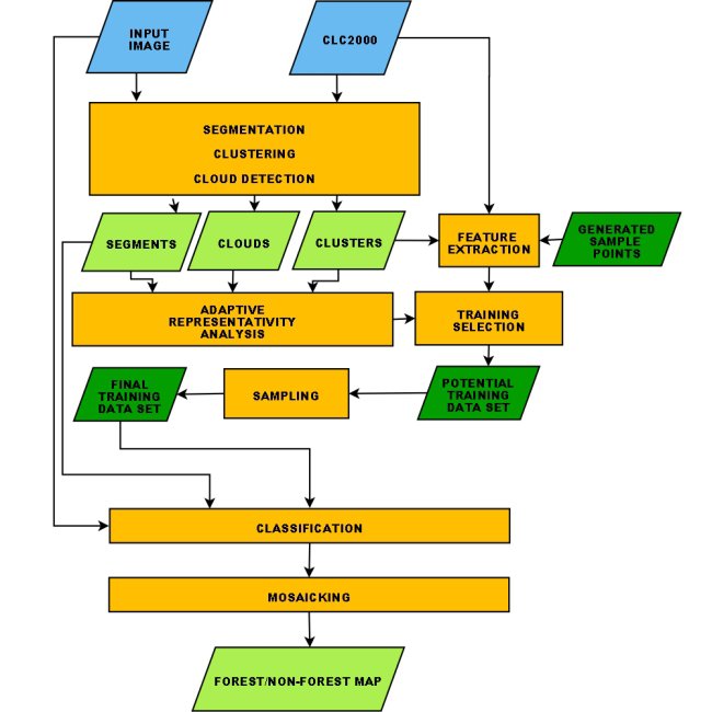
Flow chart of the algorithm used for producing the Forest Cover 2000 Map
Results
The Forest Cover Map 2000 can be downloaded from here.
Map Characteristics
The forest class of the Forest Cover 2000 map should be considered as a forest cover class rather than a forest use class. The areas cloassified as forest are therefore the ones occupied by forest and woodlands with a vegetation pattern composed of native or exotic coniferous and/or broad-leaved trees, at the moment of the Landsat images acquisition.
The following land use categories are therefore not classified as forests in the Forest Cover Map 2000 map:
- Forest roads
- Forest nurseries and regeneration area (with canopy closure less than 30%)
- Burnt areas
- Woodlands with trees smaller than 5 m height
- Temporarily unstocked areas will not be classified as forest.
Furthermore, due to the similarity of spectral signatures, the following land use classes are difficult to separate and may in certain cases also be classified as forest, as a function of tree density and background reflectance:
- Wooded parks
- Parts of olive groves
- Fruit tree plantations (e.g. orchards of apple trees)
- Agro-forestry areas
- Transitional woodlands
References
Pekkarinen, A., Reithmaier, L. & Strobl, P. 2009. Pan-European forest/non-forest mapping with Landsat ETM+ and CORINE Land Cover 2000 data. ISPRS Journal of Photogrammetry and Remote Sensing 64: 171-183.
DOI: 10.1016/j.isprsjprs.2008.09.004
The 2000 Cover Map was used to assess forest cover change in Europe in the framework of the Remote Sensing Survey of the Global Forest Resources Assessment 2010 (FRA2010). (Additional information regarding the global appraoch of the FRA2010 Remote Sensing Survey can be found here)
Forest Cover Map 2006
The Forest Cover Map 2006 map is 25m spatial resolution raster Pan-European Forest / Non Forest Map with target year 2006 derived from LISS III and SPOT 4/5 imagery and Corine Land Cover 2006 data. It includes the classes: forest, non-forest, clouds/snow and no data. The map was produced exploiting an automatic classification technique based on a Neural Network clustrering algorithm. The map covers the EU27 countries plus BA, HR, MK, LI, RS, ME, AL, NO, CH, TR, IS.
Input Data
| Satellite Imagery | |
| Sensor | IRS-P6 LISS-III, SPOT4 (HRVIR) and SPOT5 HRG) |
| Spatial Resolution | Original resolution resampled to 25m (proposed INSPIRE Grid Standard) |
| Geometric Accuracy | RMS(95%) error less than 25m |
| Geometric Reference System | ETRS89 Lambert Azimuthal Equal Area (ETRS-LAEA) |
| Acquisition Date | 2005-2006 |
| Ancillary Data | |
| Land Cover Data | CORINE Land Cover 2006 (seamless Vector layer converted to 25m raster) |
Methodology
For producing the Forest/Non-Forest map 2006 we developed and applied a fully automatic image processing methodology. In order to avoid problems linked to phenological differences between images and related problems such as equalising the radiometric content of all images, the processing was based on a scene by scene approach. For further info, see the reported references.
Results
The Forest Cover Map 2006 can be downloaded from here.
Map Characteristics
The forest class of the Forest Cover 2006 map should be considered as a forest cover class rather than a forest use class. The areas cloassified as forest are therefore the ones occupied by forest and woodlands with a vegetation pattern composed of native or exotic coniferous and/or broad-leaved trees, at the moment of the Landsat images acquisition.
The following land use categories are therefore not classified as forests in the Forest Cover Map 2006 map:
- Forest roads
- Forest nurseries and regeneration area (with canopy closure less than 30%)
- Burnt areas
- Woodlands with trees smaller than 5 m height
- Temporarily unstocked areas will not be classified as forest.
Furthermore, due to the similarity of spectral signatures, the following land use classes are difficult to separate and may in certain cases also be classified as forest, as a function of tree density and background reflectance:
- Wooded parks
- Parts of olive groves
- Fruit tree plantations (e.g. orchards of apple trees)
- Agro-forestry areas
- Transitional woodlands
References
Kempeneers, P., Sedano, F., Seebach, L., Strobl, P., San-Miguel-Ayanz, J. (2011) Data Fusion of Different Spatial Resolution Remote Sensing Images Applied to Forest-Type Mapping. IEEE Transactions on Geoscience and Remote Sensing, 49 (12), pp. 4977-4986.
DOI: 10.1109/TGRS.2011.2158548
Forest Type Map 2006
The Forest Type Map 2006 map is a 25m spatial resolution raster Pan-European Forest / Non Forest Map with target year 2006 derived from LISS III, SPOT4/5 and MODIS satellite imagery and Corine Land Cover 2006 data. It includes the classes: Broadleaved Forest, Coniferous Forest, Non-forest, Water, Clouds/snow and no data. The map was produced exploiting an automatic classification technique based on a Neural Network clustrering algorithm. The map covers the EU27 countries plus BA, HR, MK, LI, RS, ME, AL, NO, CH, TR, IS.
Input Data
| Satellite Imagery | |
| Sensor | IRS-P6 LISS-III, SPOT4 (HRVIR) and SPOT5 HRG), MODIS 250 Composites (MOD13Q) |
| Spatial Resolution | Original resolution resampled to 25m (proposed INSPIRE Grid Standard) |
| Geometric Accuracy | RMS(95%) error less than 25m |
| Geometric Reference System | ETRS89 Lambert Azimuthal Equal Area (ETRS-LAEA) |
| Acquisition Date | 2005-2006 |
| Ancillary Data | |
| Land Cover Data | CORINE Land Cover 2006 (seamless Vector layer converted to 25m raster) |
Methodology
The Forest Type Map 2006 was produced exploiting both single-time high-resolution data (LISS III and SPOT images) and multitemporal coarse spatial resolution data (MODIS composite images), with the aim to be able to distinguish between Broadleaved and Coniferous forested areas. Since the MODIS data had a spatial resolution ten times coarser than that of the LISS and SPOT imagery, a data fusion method was integrated in a two step classification approach (Kempeneers et al., 2011). In step one, the classifier created a forest map, classifying forest and non-forest only. In step two, a new classifier assigned the Forest class pixels either to the Broadleaved Forests ore Coniferous Forests classes, excluding the already identified non-forested pixels from the classification process. The multi-temporal data at medium spatial resolution were introduced only in step two. For additional details, see the reported references.
Results
The Forest Type Map 2006 can be downloaded from here.
Map Characteristics
The forest class of the Forest Type 2006 map should be considered as a forest cover class rather than a forest use class. The areas cloassified as forest are therefore the ones occupied by forest and woodlands with a vegetation pattern composed of native or exotic coniferous and/or broad-leaved trees, at the moment of the satellite images acquisition.
The Broadleaved Forest class includes therefore:
- Broad-leaved forests with more than 30% tree cover
- Broad-leaved tree plantations (e.g., Poplar, Eucalyptus)
- Evergreen broad-leaved woodlands composed of schlerophyllus trees (e.g., Quercus Ilex, Quercus Suber, Quercus Rotundifolia)
- Arborescent mattoral with schlerophyllus species
- Olive-carob forests
- Palm groves woodlands, tamarix woodlands, holly woodlands
- Broad-leaved wooded dunes
- Sub-arctic broad-leaved forests not reaching 5m in height
- Transitional woodland areas
The Coniferous Forest class includes :
- Coniferous forests with more than 30% tree cover
- Arborescent mattoral with dominating juniperous oxycedrous/phoenica
- Christmas trees plantations
- Coniferous wooded dunes
- Sub-arctic coniferous forests not reaching 5m in height
The following land use categories are not classified as forests in the Forest Type 2000 map:
- Forest roads
- Forest nurseries and regeneration area (with canopy closure less than 30%)
- Burnt areas
- Woodlands with trees smaller than 5 m height
- Temporarily unstocked areas (i.e., clear cuts).
Furthermore, due to the similarity of spectral signatures, the following land use classes are difficult to separate and may in certain cases also be classified as forest, as a function of tree density and background reflectance:
- Wooded parks
- Parts of olive groves
- Fruit tree plantations (e.g. orchards of apple trees)
- Agro-forestry areas
- Transitional woodlands
References
Kempeneers, P., Sedano, F., Seebach, L., Strobl, P., San-Miguel-Ayanz, J. (2011) Data Fusion of Different Spatial Resolution Remote Sensing Images Applied to Forest-Type Mapping. IEEE Transactions on Geoscience and Remote Sensing, 49 (12), pp. 4977-4986.
DOI: 10.1109/TGRS.2011.2158548
To download the forest data please take the following steps:
- Select the forest data to download from the drop down menu.
- Click on the grid area of interest to download a geotif formatted raster map