
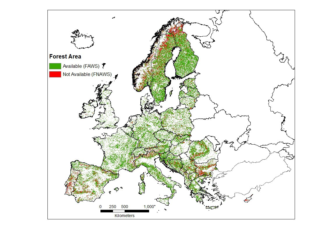
Knowledge of the extent and spatial distribution of Forest Available for Wood Supply (FAWS) is key for the forest bioeconomy. In the context of the framework contract with the National Forest Inventory (NFI) organizations, JRC is aiming to assessing, with a harmonized approach, the main restrictions to wood availability and the related forest area and biomass stock. The Forest Not Available for Wood Supply (FNAWS) was defined as “Forests where there are environmental, social or economic restrictions that have a significant impact on the current or potential supply of wood”, quantified using a harmonized list of potential/likely restrictions. The average FNAWS in the selected countries were about 15% for area and 9% for biomass. The economic restrictions accounted for most of the FNAWS, followed by environmental restrictions, while social restrictions had a marginal role. The main restrictions were related to forest productivity, slope, accessibility and protected areas (Alberdi et al., in prep.).
This information, produced by the NFIs, is integrated with national statistics from FOREST EUROPE (2015) for the remaining countries and then combined with existing spatial datasets to map FAWS over Europe. We use an “approach by exclusion”, which is to map the forest that is not available due to various constraints (FNAWS), and subtract this area from the existing forest area. We use the Copernicus HRL Forest Type map 2015 as a base map of forest areas. Then, we map FNAWS areas using the following restrictions: high slope, high altitude, protected areas, protected species, low accessibility (distance to roads), and unproductive forests. Due to the large differences in natural environment and forestry practices between regions in Europe, the thresholds for each restrictions (e.g., maximum slope) arecalibrated at country scale. The output of this analysis is a preliminary map of FAWS in Europe at 100 m spatial resolution (Avitabile et al., 2018). This map will be improved with additional country-specific information on restrictions to wood availability thanks to the ongoing collaboration with additional NFI agencies in Europe.
References
Avitabile, V., Camia, A., Mubareka, S., Alberdi, I., Hernández, L., Klatt, S., Gschwantner, T., Riedel, T., Lanz, A., Freudenschuß, A., Snorrason, A., Fischer, C., Castro Rego, F., Marin, G., Cañellas, I., Redmond, J., Fridman, J., Nunes, L., Rizzo, M., Bosela, M., Kucera, M., Notarangelo, M., Gasparini, P., Tomter, S. M., Wurpillot, S., Seben V., (2018). Mapping forest biomass available for wood supply in Europe. EGU General Assembly Conference Abstracts, Vol. 20, p. 8601.